
Contagem topographic map
Click on the map to display elevation.
Contagem
The city belongs to the metropolitan mesoregion and to the microregion of Belo Horizonte, has a territorial extension of 195.2 square kilometres (75.4 square miles), and borders the municipalities of Ribeirão das Neves, Esmeraldas, Betim, Ibirité and Belo Horizonte. The elevation of the city hall is 939 metres (3,081 feet).
About this map
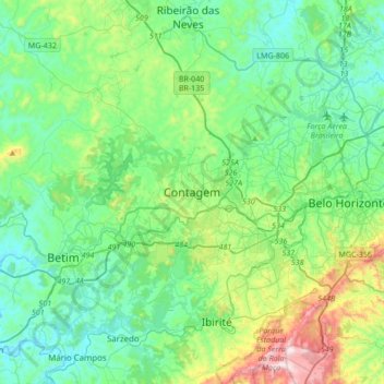
Name: Contagem topographic map, elevation, terrain.
Average elevation: 890 m
Minimum elevation: 711 m
Maximum elevation: 1,508 m
Other topographic maps
Click on a map to view its topography, its elevation and its terrain.
Parque Industrial
Brazil > Minas Gerais > Região Metropolitana de Belo Horizonte > Contagem
Average elevation: 942 m
Nova Contagem
Brazil > Minas Gerais > Região Metropolitana de Belo Horizonte > Contagem
Average elevation: 907 m
Vila Beneves
Brazil > Minas Gerais > Região Metropolitana de Belo Horizonte > Contagem
Average elevation: 897 m