Geolocate

Hamedan topographic map

Click on the map to display elevation.

Hamedan

Hamadan spot (light blue in center) in Hamadan province topography map

Wikipedia (CC-BY-SA 3.0)

About this map

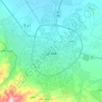
Name: Hamedan topographic map, elevation, terrain.

Location: Hamedan, Central District, Hamedan County, Hamadan Province, Iran (34.75190 48.46645 34.85043 48.59163)

Average elevation: 1,880 m

Minimum elevation: 1,742 m

Maximum elevation: 2,640 m

Other topographic maps

Click on a map to view its topography, its elevation and its terrain.

Dizaj Town

Iran > Hamadan Province > Hamedan County > Hamedan > Dizaj Town

Average elevation: 1,811 m

Gear up for your next adventure:

🧥Breathable Waterproof Jackets - Essential rain protection for the unpredictable British climate
🧢Thermal Beanie Hats - Prevent heat loss from the head in windy summit conditions
🧼Technical Clothing Wash - Special soap to clean and restore waterproof membranes
Insulated Travel Mugs - Keep drinks hot while surveying the landscape from a summit
🪢Paracord - Multi-purpose cord for camping and survival

As an Amazon Associate, this site earns from qualifying purchases at no extra cost to you.