
Botshabelo topographic map
Click on the map to display elevation.
About this map
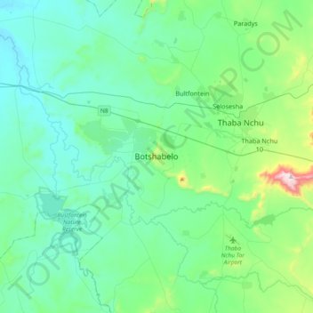
Name: Botshabelo topographic map, elevation, terrain.
Average elevation: 1,454 m
Minimum elevation: 1,322 m
Maximum elevation: 2,123 m
Other topographic maps
Click on a map to view its topography, its elevation and its terrain.
Rustfontein Dam
South Africa > Free State > Mangaung Metropolitan Municipality
Average elevation: 1,375 m
Mangaung Ward 12
South Africa > Free State > Mangaung Metropolitan Municipality > Bloemfontein
Average elevation: 1,398 m
Klein-Modder
South Africa > Free State > Mangaung Metropolitan Municipality > Botshabelo
Average elevation: 1,392 m
Mangaung Ward 26
South Africa > Free State > Mangaung Metropolitan Municipality
Average elevation: 1,338 m
Bloemspruit
South Africa > Free State > Mangaung Metropolitan Municipality > Bloemfontein
Average elevation: 1,376 m
Wag-n'-Bietjie Park
South Africa > Free State > Mangaung Metropolitan Municipality > Bloemfontein
Average elevation: 1,411 m