
Apulia topographic map
Interactive map
Click on the map to display elevation.
About this map
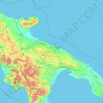
Name: Apulia topographic map, elevation, terrain.
Location: Apulia, Italy (39.78959 14.93419 42.22648 18.52051)
Average elevation: 167 m
Minimum elevation: -4 m
Maximum elevation: 2,151 m
Other topographic maps
Click on a map to view its topography, its elevation and its terrain.
Bannia / Banìe
Italy > Friuli – Venezia Giulia > Pordenone / Pordenon > Fiume Veneto
Average elevation: 21 m
Matterhorn
Italy > Aosta Valley > Valtournenche
In 1999, the summit height was precisely determined to be at 4,477.54 m (14,690 ft) above sea level by using Global Positioning System technology as part of the TOWER Project (Top of the World Elevations Remeasurement) and to an accuracy of less than one centimetre, which allows future changes to be tracked.
Average elevation: 3,295 m
Monte Arcosu
Italy > Sardinia > Casteddu/Cagliari > Siliqua
Monte Arcosu is a mountain in the Sulcis massif, in southern Sardinia, Italy. It has an elevation of 948 metres (3,110 ft).
Average elevation: 546 m
Siebeneich - Settequerce
Italy > Trentino – Alto Adige/Südtirol > South Tyrol
Average elevation: 427 m
Matterhorn
Italy > Aosta Valley > Valtournenche
In 1999, the summit height was precisely determined to be at 4,477.54 m (14,690 ft) above sea level by using Global Positioning System technology as part of the TOWER Project (Top of the World Elevations Remeasurement) and to an accuracy of less than one centimetre, which allows future changes to be tracked.
Average elevation: 3,295 m
La cerqua di Roncacé (quercia secolare)
Italy > Abruzzo > Teramo > Controguerra > San Giovanni II
Average elevation: 197 m
Montemaggiore / Brezje
Italy > Friuli – Venezia Giulia > Udine / Udin / Videm > Taipana
Average elevation: 817 m
Mount Vesuvius
Italy > Campania > Naples > Trecase
The volcano's slopes are scarred by lava flows, while the rest are heavily vegetated, with scrub and forests at higher altitudes and vineyards lower down.
Average elevation: 862 m
Bocca di Valle
Italy > Trentino – Alto Adige/Südtirol > Provincia di Trento > Bondone
Average elevation: 1,258 m
Hintere Schwärze
Italy > Trentino – Alto Adige/Südtirol > South Tyrol > Schnals - Senales
Average elevation: 3,152 m
valle dell'Anza
Italy > Trentino – Alto Adige/Südtirol > Provincia di Trento > Levico Terme > Selva di Levico > Masi Rossi
Average elevation: 807 m
Ortler - Ortles
Italy > Trentino – Alto Adige/Südtirol > South Tyrol > Stilfs - Stelvio
The Ortler was first climbed by Josef Pichler [de] ("Pseirer-Josele"), a chamois hunter from St. Leonhard in Passeier, and his companions Johann Leitner and Johann Klausner from Zell am Ziller on 27 September 1804. The ascent had been a request of Archduke Johann of Austria, who felt strongly that after the…
Average elevation: 3,175 m
Breuil-Cervinia
The ski area is very large and guarantees good snow quality during the season, being at a high altitude (2,050 m to 3,500 m).
Average elevation: 2,376 m
Telfen - Lanzin
Italy > Trentino – Alto Adige/Südtirol > South Tyrol > Kastelruth - Castelrotto > Kastelruth - Ciastel - Castelrotto
Average elevation: 1,035 m
Sulden - Solda
Italy > Trentino – Alto Adige/Südtirol > South Tyrol > Stilfs - Stelvio
Average elevation: 2,232 m
Sant'Andrea oltre il Muson
Italy > Veneto > Province of Treviso > Castelfranco Veneto
Average elevation: 38 m
Giardini Botanici Villa Taranto
Italy > Piedmont > Verbano-Cusio-Ossola > Verbania
Average elevation: 210 m
Cortina
Italy > Trentino – Alto Adige/Südtirol > Provincia di Trento > Vermiglio
Average elevation: 1,534 m
Vaiano
Italy > Umbria > Perugia > Castiglione del Lago
Vaiano is a frazione of the comune of Castiglione del Lago in the Province of Perugia, Umbria, central Italy. It stands at an elevation of 371 metres above sea level. At the time of the Istat census of 2001 it had 234 inhabitants.
Average elevation: 306 m
St. Magdalena - Santa Maddalena in Casies
Italy > Trentino – Alto Adige/Südtirol > South Tyrol > Gsies - Valle di Casies
Average elevation: 1,772 m