
Make a donation
Gear up for your next adventure:
As an Amazon Associate, this site earns from qualifying purchases at no extra cost to you.
Trieste topographic map
Click on the map to display elevation.
Make a donation
Gear up for your next adventure:
As an Amazon Associate, this site earns from qualifying purchases at no extra cost to you.
Trieste
Trieste lies in the northernmost part of the high Adriatic in northeastern Italy, near the border with Slovenia. The city lies on the Gulf of Trieste. Built mostly on a hillside that becomes a mountain, Trieste's urban territory lies at the foot of an imposing escarpment that comes down abruptly from the Karst Plateau towards the sea. The karst hills delimiting the city reach an elevation of 458 metres (1,503 feet) above sea level. It lies at the junction point of the Italian geographical region, the Balkan Peninsula, and Mitteleuropan Area.
Make a donation
Gear up for your next adventure:
As an Amazon Associate, this site earns from qualifying purchases at no extra cost to you.
About this map
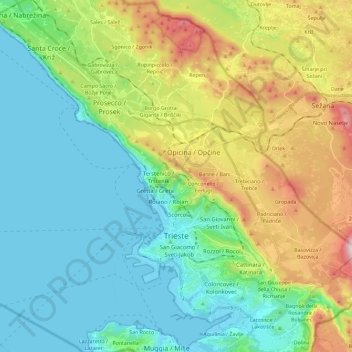
Name: Trieste topographic map, elevation, terrain.
Location: Trieste, Friuli – Venezia Giulia, 34121-34151, Italy (45.60680 13.66832 45.74662 13.89831)
Average elevation: 184 m
Minimum elevation: -1 m
Maximum elevation: 647 m
Make a donation
Gear up for your next adventure:
As an Amazon Associate, this site earns from qualifying purchases at no extra cost to you.
Other topographic maps
Click on a map to view its topography, its elevation and its terrain.
Make a donation
Gear up for your next adventure:
As an Amazon Associate, this site earns from qualifying purchases at no extra cost to you.