Geolocate

Linz topographic map

Click on the map to display elevation.

About this map

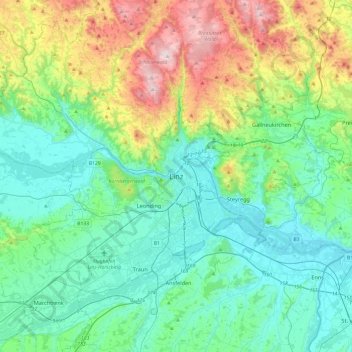
Name: Linz topographic map, elevation, terrain.

Location: Linz, Upper Austria, 4010, Austria (48.14591 14.12620 48.46591 14.44620)

Average elevation: 410 m

Minimum elevation: 238 m

Maximum elevation: 942 m

Gear up for your next adventure:

🧼Technical Clothing Wash - Special soap to clean and restore waterproof membranes
🥾Hiking Boots - Waterproof and durable boots for long-distance hiking in the UK
📍Handheld GPS Navigators - Reliable satellite navigation for hiking and off-road exploration
🧼Biodegradable Soap - Leave-no-trace hygiene for multi-day mountain treks
🌂Windproof Trekking Umbrellas - Surprising but effective rain protection on low-wind trails

As an Amazon Associate, this site earns from qualifying purchases at no extra cost to you.