
Zhengzhou topographic map
Interactive map
Click on the map to display elevation.
About this map
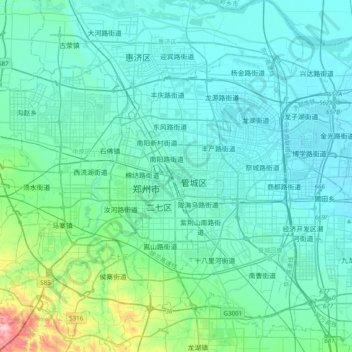
Name: Zhengzhou topographic map, elevation, terrain.
Average elevation: 122 m
Minimum elevation: 81 m
Maximum elevation: 413 m
Other topographic maps
Click on a map to view its topography, its elevation and its terrain.
Guancheng Hui District
Guancheng Hui District has an elevation ranging from about 100 metres (330 ft) to 140 metres (460 ft) above sea level.
Average elevation: 112 m