
Make a donation
Gear up for your next adventure:
As an Amazon Associate, this site earns from qualifying purchases at no extra cost to you.
Morgan Heights topographic map
Click on the map to display elevation.
Make a donation
Gear up for your next adventure:
As an Amazon Associate, this site earns from qualifying purchases at no extra cost to you.
About this map
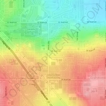
Name: Morgan Heights topographic map, elevation, terrain.
Average elevation: 61 m
Minimum elevation: 0 m
Maximum elevation: 116 m
Make a donation
Gear up for your next adventure:
As an Amazon Associate, this site earns from qualifying purchases at no extra cost to you.
Other topographic maps
Click on a map to view its topography, its elevation and its terrain.
Surrey Lake
Canada > British Columbia > Metro Vancouver Regional District > Surrey
Average elevation: 26 m
Cloverdale
Canada > British Columbia > Metro Vancouver Regional District > Surrey
Average elevation: 24 m
Make a donation
Gear up for your next adventure:
As an Amazon Associate, this site earns from qualifying purchases at no extra cost to you.
Serpentine Heights Park
Canada > British Columbia > Metro Vancouver Regional District > Surrey
Average elevation: 59 m
South Surrey
Canada > British Columbia > Metro Vancouver Regional District > Surrey
Average elevation: 28 m
Guildford
Canada > British Columbia > Metro Vancouver Regional District > Surrey
Average elevation: 46 m
Surrey--Newton
Canada > British Columbia > Metro Vancouver Regional District > Surrey
Average elevation: 71 m
Make a donation
Gear up for your next adventure:
As an Amazon Associate, this site earns from qualifying purchases at no extra cost to you.
Green Timbers Lake
Canada > British Columbia > Metro Vancouver Regional District > Surrey
Average elevation: 95 m
South Surrey
Canada > British Columbia > Metro Vancouver Regional District > Surrey
Average elevation: 28 m
Cresent Rock Beach
Canada > British Columbia > Metro Vancouver Regional District > Surrey
Average elevation: 29 m
South Surrey
Canada > British Columbia > Metro Vancouver Regional District > Surrey
Average elevation: 28 m
Make a donation
Gear up for your next adventure:
As an Amazon Associate, this site earns from qualifying purchases at no extra cost to you.