
Make a donation
Gear up for your next adventure:
As an Amazon Associate, this site earns from qualifying purchases at no extra cost to you.
Accrington topographic map
Click on the map to display elevation.
Make a donation
Gear up for your next adventure:
As an Amazon Associate, this site earns from qualifying purchases at no extra cost to you.
Accrington
Geographical coordinates: 53° 46' 0" North, 2° 21' 0" West. Height above sea level: there is a spot height outside the Market Hall which is 133.5 metres (438 ft) the benchmark on the side of the neighbouring Town Hall is 441.10 feet (134.45 m). The highest height in the town is 320 metres (1,050 ft) which is in Baxenden and the lowest at the town hall which is at 132.5 metres (435 ft). Accrington is lowering in elevation travelling northwards towards the Hyndburn. North of the river the elevation rises again, crossing over the watershed between Hyndburn and River Calder, both eventually leading into River Ribble via separate routes. The Hyndburn district further north eventually falls to the modest elevation of the Calder river banks.
Make a donation
Gear up for your next adventure:
As an Amazon Associate, this site earns from qualifying purchases at no extra cost to you.
About this map
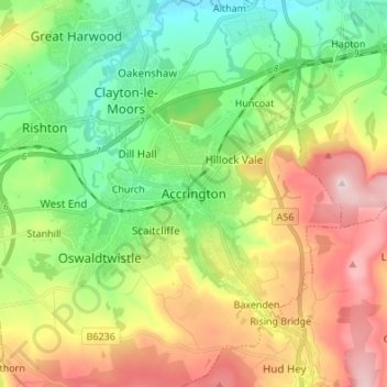
Name: Accrington topographic map, elevation, terrain.
Average elevation: 199 m
Minimum elevation: 62 m
Maximum elevation: 408 m
Lancashire trails, hiking, mountain biking, running and outdoor activities
Make a donation
Gear up for your next adventure:
As an Amazon Associate, this site earns from qualifying purchases at no extra cost to you.
Other topographic maps
Click on a map to view its topography, its elevation and its terrain.
Oswaldtwistle Moor
United Kingdom > England > Lancashire > Hyndburn > Green Haworth > Cocker Brook
Average elevation: 300 m