
Mauranipur topographic map
Interactive map
Click on the map to display elevation.
About this map
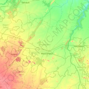
Name: Mauranipur topographic map, elevation, terrain.
Location: Mauranipur, Jhansi, Uttar Pradesh, India (25.10647 78.78712 25.48543 79.35127)
Average elevation: 218 m
Minimum elevation: 135 m
Maximum elevation: 395 m
Other topographic maps
Click on a map to view its topography, its elevation and its terrain.
Gairaha
India > Uttar Pradesh > Mauranipur > Gairaha
Gairaha, Mauranipur, Jhansi, Uttar Pradesh, 203304, India
Average elevation: 225 m