
建水县 topographic map
Interactive map
Click on the map to display elevation.
About this map
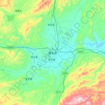
Name: 建水县 topographic map, elevation, terrain.
Location: 建水县, 红河哈尼族彝族自治州, 云南省, 中国 (23.47611 102.66635 23.79611 102.98635)
Average elevation: 1,571 m
Minimum elevation: 1,266 m
Maximum elevation: 2,505 m
县内最高峰为焕文山五老峰,海拔2515米。红河岸边的阿土村海拔仅230米,为境内海拔最低点。
Other topographic maps
Click on a map to view its topography, its elevation and its terrain.