
Xã Hòa Ninh topographic map
Interactive map
Click on the map to display elevation.
About this map
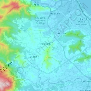
Name: Xã Hòa Ninh topographic map, elevation, terrain.
Location: Xã Hòa Ninh, Hòa Vang District, Đà Nẵng, Vietnam (15.99451 107.95789 16.10739 108.09236)
Average elevation: 108 m
Minimum elevation: -2 m
Maximum elevation: 989 m
Other topographic maps
Click on a map to view its topography, its elevation and its terrain.