
Abradinou topographic map
Interactive map
Click on the map to display elevation.
About this map
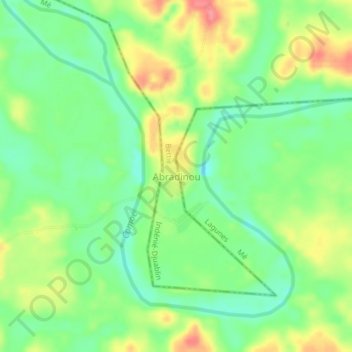
Name: Abradinou topographic map, elevation, terrain.
Location: Abradinou, Bettié, Indénié-Djuablin, Comoé, Côte d’Ivoire (6.16731 -3.47493 6.20731 -3.43493)
Average elevation: 111 m
Minimum elevation: 78 m
Maximum elevation: 159 m
Other topographic maps
Click on a map to view its topography, its elevation and its terrain.
Akakomoékro
Côte d’Ivoire > Comoé > Bettié
Akakomoékro, Bettié, Indénié-Djuablin, Comoé, Côte d’Ivoire
Average elevation: 128 m
Bettié
Côte d’Ivoire > Comoé > Bettié
Bettié, Indénié-Djuablin, Comoé, Côte d’Ivoire
Average elevation: 113 m