
La Concha topographic map
Interactive map
Click on the map to display elevation.
About this map
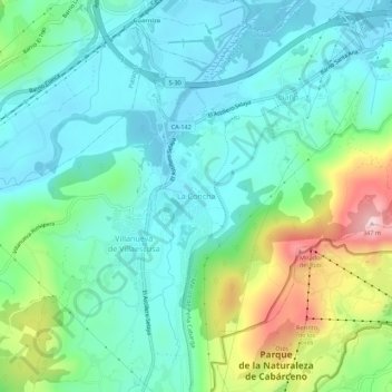
Name: La Concha topographic map, elevation, terrain.
Location: La Concha, Villaescusa, Cantabria, 39728, España (43.35281 -3.87258 43.39281 -3.83258)
Average elevation: 87 m
Minimum elevation: -1 m
Maximum elevation: 338 m
Other topographic maps
Click on a map to view its topography, its elevation and its terrain.
Sierra de Villacimera
España > Cantabria > Villaescusa
Sierra de Villacimera, Villaescusa, Comarca de Santander, Cantabria, 39690, España
Average elevation: 125 m