
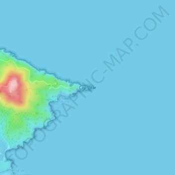
Cap Béar topographic map
Interactive map
Click on the map to display elevation.
About this map
Name: Cap Béar topographic map, elevation, terrain.
Average elevation: 10 m
Minimum elevation: 0 m
Maximum elevation: 195 m
Other topographic maps
Click on a map to view its topography, its elevation and its terrain.
Madeloc
France > Occitanie > Pyrénées-Orientales > Port-Vendres
Madeloc, Port-Vendres, Céret, Pyrénées-Orientales, Occitanie, France métropolitaine, 66660, France
Average elevation: 315 m
Cosprons
France > Occitanie > Pyrénées-Orientales > Port-Vendres > Cosprons
Cosprons, Port-Vendres, Céret, Pyrénées-Orientales, Occitanie, France métropolitaine, 66660, France
Average elevation: 108 m
Phare du Cap Béar
France > Occitanie > Pyrénées-Orientales > Port-Vendres
Phare du Cap Béar, Route du Cap Béar, Port-Vendres, Céret, Pyrénées-Orientales, Occitanie, France métropolitaine, 66660, France
Average elevation: 13 m