Geolocate

San Fernando topographic map

Click on the map to display elevation.

About this map
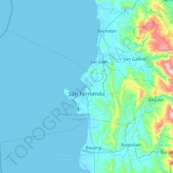
Name: San Fernando topographic map, elevation, terrain.

Location: San Fernando, La Union, Ilocos Region, 2500, Philippines (16.53417 120.13646 16.72165 120.43623)

Average elevation: 68 m

Minimum elevation: -1 m

Maximum elevation: 734 m

Other topographic maps

Click on a map to view its topography, its elevation and its terrain.
Santol

Philippines > La Union

Average elevation: 209 m

Balaoan

Philippines > La Union

Average elevation: 46 m

Aringay

Philippines > La Union > Aringay

Average elevation: 37 m

Paagan

Philippines > La Union > Santol

Average elevation: 47 m

Puguil

Philippines > La Union

Average elevation: 517 m

Luna

Philippines > La Union

Average elevation: 8 m

San Martin

Philippines > La Union > Bacnotan

Average elevation: 16 m

Liquicia

Philippines > La Union > Caba

Average elevation: 124 m

Urbiztondo

Philippines > La Union

Average elevation: 17 m

Bangar

Philippines > La Union > Bangar

Average elevation: 18 m

Gear up for your next adventure:

🎿Telescopic Trekking Poles - Reduces knee strain on steep topographic descents
🧤Thermal Touchscreen Gloves - Stay warm while operating your GPS or smartphone camera
🧷Tenacious Repair Tape - Instant fix for torn tents, jackets, or dry bags
⛺Lightweight Solo Tents - Backpacking tents designed for wild camping in the UK highlands
🔪Outdoor Multi-Tools - Versatile tools for gear repairs and food prep in the wild

As an Amazon Associate, this site earns from qualifying purchases at no extra cost to you.