
Herschbroich topographic map
Interactive map
Click on the map to display elevation.
About this map
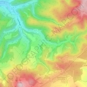
Name: Herschbroich topographic map, elevation, terrain.
Average elevation: 479 m
Minimum elevation: 316 m
Maximum elevation: 653 m
Seit Beginn der Aufzeichnungen Anfang des 19. Jahrhunderts schwankte die Bevölkerungszahl wenig und liegt heute nur unwesentlich höher als vor etwa 200 Jahren.
Other topographic maps
Click on a map to view its topography, its elevation and its terrain.
Bad Neuenahr-Ahrweiler
Deutschland > Rheinland-Pfalz > Landkreis Ahrweiler
Bad Neuenahr-Ahrweiler, Landkreis Ahrweiler, Rheinland-Pfalz, 53474, Deutschland
Average elevation: 257 m
Walporzheim
Deutschland > Rheinland-Pfalz > Landkreis Ahrweiler > Bad Neuenahr-Ahrweiler
Walporzheim, Bad Neuenahr-Ahrweiler, Landkreis Ahrweiler, Rheinland-Pfalz, Deutschland
Average elevation: 219 m