
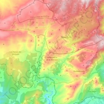
Santa María de la Alameda topographic map
Interactive map
Click on the map to display elevation.
About this map
Name: Santa María de la Alameda topographic map, elevation, terrain.
Average elevation: 1,339 m
Minimum elevation: 872 m
Maximum elevation: 1,783 m
Originally a group of cattle-raising hamlets, the municipality comprises different settlements: Las Herreras, El Pimpollar, La Hoya, Navalespino, La Paradilla, Robledondo, Santa María de la Alameda and Santa María Estación. In time, the nucleus of "Santa María Estación", developed around the railway station, has grown to become the most populated settlement. The capital of the municipality (the namesake "Santa María de la Alameda") is located at an elevation of 1,409 metres. The municipality covers an area of 74.41 km2, including the exclave of Dehesa de la Cepeda, a mostly pasture area geographically located between the provinces of Ávila and Segovia in the autonomous community of Castile and León.
Other topographic maps
Click on a map to view its topography, its elevation and its terrain.
Navalagamella
Spain > Community of Madrid > Sierra Oeste
Navalagamella, Sierra Oeste, Community of Madrid, 28212, Spain
Average elevation: 718 m