
Maxmo topographic map
Click on the map to display elevation.
Maxmo
The name Vörå was first mentioned in documents in 1367 and the parish of Vörå was first mentioned in 1443. The parish name has been the subject of both historical and toponymy research since at least 1734. It has been debated whether the name is originally Swedish Vörå or Finnish Vöyri and what the basis for the name was. The parish of Vörå is located on a historical language border. Its village names and many family names are undoubtedly of Finnish origin. It is estimated that the population only became Swedish during the 16th century. Therefore, it is reasonable to assume that the parish name itself is of Finnish origin. Lars Huldén believed that the original name is Finnish and one-part, possibly derived from the word vieru. Its diphthong reverts to a long e and is seen in the old spelling Weru. Huldén believed that the factual basis for the name was its topography: an edge, a cliff, or a place from which the earth has rolled away.
About this map
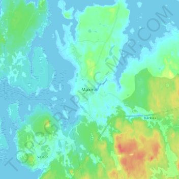
Name: Maxmo topographic map, elevation, terrain.
Location: Maxmo, Vörå, Ostrobothnia, Mainland Finland, 66640, Finland (63.17413 22.01561 63.25413 22.09561)
Average elevation: 9 m
Minimum elevation: -2 m
Maximum elevation: 45 m
Other topographic maps
Click on a map to view its topography, its elevation and its terrain.
Vörå
The name Vörå was first mentioned in documents in 1367 and the parish of Vörå was first mentioned in 1443. The parish name has been the subject of both historical and toponymy research since at least 1734. It has been debated whether the name is originally Swedish Vörå or Finnish Vöyri and what the…
Average elevation: 15 m