Geolocate

Yorktown topographic map

Click on the map to display elevation.

About this map

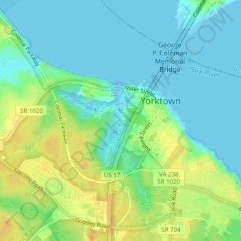
Name: Yorktown topographic map, elevation, terrain.

Location: Yorktown, York County, Virginia, United States (37.22878 -76.52541 37.24255 -76.50458)

Average elevation: 10 m

Minimum elevation: -1 m

Maximum elevation: 26 m

Gear up for your next adventure:

📷Outdoor Action Cameras - Cameras designed for hiking and adventure
🦶Anti-Blister Balms - Protect your feet before long topographic expeditions
🌄Outdoor Binoculars - Compact binoculars for landscape observation
🥾Hiking Boot Waterproofing Wax - Maintain the lifespan of your leather trekking boots
🎒Hiking Daypacks - Compact backpacks ideal for short hikes and excursions

As an Amazon Associate, this site earns from qualifying purchases at no extra cost to you.