
Saint-Baudille topographic map
Interactive map
Click on the map to display elevation.
About this map
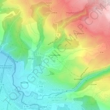
Name: Saint-Baudille topographic map, elevation, terrain.
Average elevation: 357 m
Minimum elevation: 208 m
Maximum elevation: 572 m
Other topographic maps
Click on a map to view its topography, its elevation and its terrain.
Les Fargues
France > Occitanie > Tarn > Pont-de-Larn > Pont-de-l'Arn > Les Fargues
Les Fargues, Pont-de-l'Arn, Pont-de-Larn, Castres, Tarn, Occitanie, France métropolitaine, 81660, France
Average elevation: 357 m
Montlédier
France > Occitanie > Tarn > Pont-de-Larn > Pont-de-l'Arn
Montlédier, Pont-de-l'Arn, Pont-de-Larn, Castres, Tarn, Occitanie, France métropolitaine, 81660, France
Average elevation: 341 m