
Make a donation
Gear up for your next adventure:
As an Amazon Associate, this site earns from qualifying purchases at no extra cost to you.
Buni Zom topographic map
Click on the map to display elevation.
Make a donation
Gear up for your next adventure:
As an Amazon Associate, this site earns from qualifying purchases at no extra cost to you.
Buni Zom
The Buni Zom group is a prominent mountain area of Chitral, in the Hindu Raj range of Pakistan. Buni Zom (main) is the highest peak of the group with an elevation of 6,542 m (21,463 ft). It is located about 50 km (30 mi) northeast of the town of Chitral, and about 50 km (30 mi) east of Tirich Mir (7,708 m), the highest peak in the Hindu Kush.
Make a donation
Gear up for your next adventure:
As an Amazon Associate, this site earns from qualifying purchases at no extra cost to you.
About this map
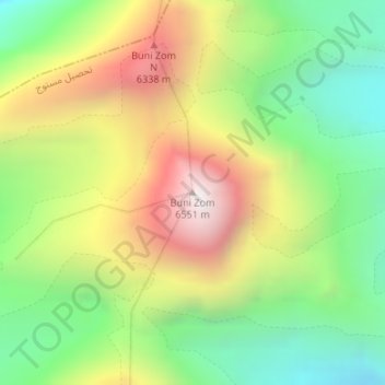
Name: Buni Zom topographic map, elevation, terrain.
Average elevation: 5,757 m
Minimum elevation: 5,183 m
Maximum elevation: 6,520 m
Make a donation
Gear up for your next adventure:
As an Amazon Associate, this site earns from qualifying purchases at no extra cost to you.