Geolocate

Bandy topographic map

Click on the map to display elevation.

About this map

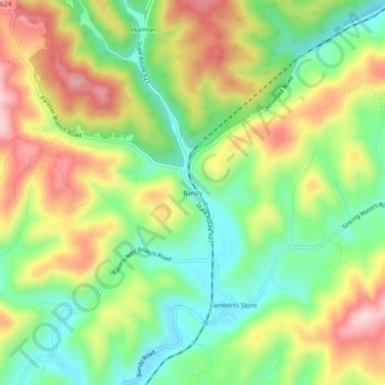
Name: Bandy topographic map, elevation, terrain.

Location: Bandy, Tazewell County, Virginia, United States (37.12289 -81.72095 37.16289 -81.68095)

Average elevation: 734 m

Minimum elevation: 625 m

Maximum elevation: 874 m

Other topographic maps

Click on a map to view its topography, its elevation and its terrain.

Cedar Bluff

United States > Virginia > Tazewell County

Average elevation: 673 m

Gratton

United States > Virginia > Tazewell County > Gratton

Average elevation: 959 m

Bluefield

United States > Virginia > Tazewell County

Average elevation: 849 m

Cedar Bluff

United States > Virginia > Tazewell County

Average elevation: 673 m

Gear up for your next adventure:

Altimeter Watches - Watches measuring altitude for mountain activities
🧗Locking Carabiners - Secure gear to your pack or for light technical use
🔥Reusable Hand Warmers - Maintain dexterity in your fingers for precise map handling
📦Dry Bags - Waterproof bags to protect gear from rain
🚲Cycling GPS Computers - Track elevation and topographic routes on two wheels

As an Amazon Associate, this site earns from qualifying purchases at no extra cost to you.