
Hofheim am Taunus topographic map
Interactive map
Click on the map to display elevation.
Hofheim am Taunus
Hofheim was also mentioned in the Topographia Hassiae. Which said that.
About this map
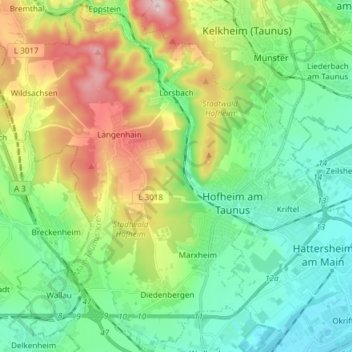
Name: Hofheim am Taunus topographic map, elevation, terrain.
Location: Hofheim am Taunus, Main-Taunus-Kreis, Hesse, 65719, Germany (50.04564 8.34332 50.14243 8.47436)
Average elevation: 198 m
Minimum elevation: 88 m
Maximum elevation: 440 m