Geolocate

Alexander Township topographic map

Click on the map to display elevation.

About this map

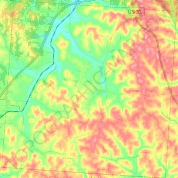
Name: Alexander Township topographic map, elevation, terrain.

Location: Alexander Township, Athens County, Ohio, United States (39.19349 -82.19218 39.28865 -82.07096)

Average elevation: 250 m

Minimum elevation: 196 m

Maximum elevation: 307 m

Other topographic maps

Click on a map to view its topography, its elevation and its terrain.

Shade

United States > Ohio > Athens County

Average elevation: 258 m

La Mar Heights

United States > Ohio > Athens County > Athens

Average elevation: 238 m

La Mar Heights

United States > Ohio > Athens County > Athens

Average elevation: 238 m

Stringtown

United States > Ohio > Athens County

Average elevation: 230 m

Millfield

United States > Ohio > Athens County

Average elevation: 237 m

Millfield

United States > Ohio > Athens County > Millfield

Average elevation: 237 m

Gear up for your next adventure:

🧼Camping Hygiene Kits - Compact hygiene essentials for outdoor stays
🗺️Scratch-off Peak Maps - Track your progress climbing Munros or Wainwrights
GPS Outdoor Watches - Watches with GPS tracking for hiking and exploration
🧭Orienteering Compasses - Accurate compasses for map-based navigation
💧Hydration Reservoirs - Convenient water bladders for hands-free drinking on the move

As an Amazon Associate, this site earns from qualifying purchases at no extra cost to you.