
Make a donation
Gear up for your next adventure:
As an Amazon Associate, this site earns from qualifying purchases at no extra cost to you.
Flawith topographic map
Click on the map to display elevation.
Make a donation
Gear up for your next adventure:
As an Amazon Associate, this site earns from qualifying purchases at no extra cost to you.
About this map
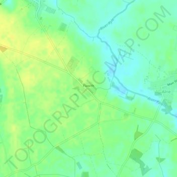
Name: Flawith topographic map, elevation, terrain.
Average elevation: 21 m
Minimum elevation: 10 m
Maximum elevation: 32 m
North Yorkshire trails, hiking, mountain biking, running and outdoor activities
Make a donation
Gear up for your next adventure:
As an Amazon Associate, this site earns from qualifying purchases at no extra cost to you.
Other topographic maps
Click on a map to view its topography, its elevation and its terrain.
The Wainstones
United Kingdom > England > North Yorkshire > Hambleton > Great Broughton
Average elevation: 231 m
Little Crakehall
United Kingdom > England > North Yorkshire > Hambleton > Little Crakehall
Average elevation: 61 m
Make a donation
Gear up for your next adventure:
As an Amazon Associate, this site earns from qualifying purchases at no extra cost to you.
Seave Green
United Kingdom > England > North Yorkshire > Hambleton > Chop Gate > Seave Green
Average elevation: 264 m
Great Crakehall
United Kingdom > England > North Yorkshire > Hambleton > Great Crakehall
Average elevation: 60 m