
Make a donation
Gear up for your next adventure:
As an Amazon Associate, this site earns from qualifying purchases at no extra cost to you.
Purwodadi topographic map
Click on the map to display elevation.
Make a donation
Gear up for your next adventure:
As an Amazon Associate, this site earns from qualifying purchases at no extra cost to you.
About this map
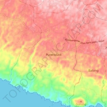
Name: Purwodadi topographic map, elevation, terrain.
Average elevation: 171 m
Minimum elevation: 0 m
Maximum elevation: 291 m
Make a donation
Gear up for your next adventure:
As an Amazon Associate, this site earns from qualifying purchases at no extra cost to you.
Other topographic maps
Click on a map to view its topography, its elevation and its terrain.
Pantai Drini
Indonesia > Special Region of Yogyakarta > Gunung Kidul Regency > Banjarejo
Average elevation: 20 m
Gedangan
Indonesia > Special Region of Yogyakarta > Gunung Kidul Regency > Gedangsari > Hargomulyo
Average elevation: 325 m
Karang Sari
Indonesia > Special Region of Yogyakarta > Gunung Kidul Regency > Karangsari
Average elevation: 348 m
Pantai Ngandong
Indonesia > Special Region of Yogyakarta > Gunung Kidul Regency > Sidoharjo
Average elevation: 23 m
Make a donation
Gear up for your next adventure:
As an Amazon Associate, this site earns from qualifying purchases at no extra cost to you.
Pantai Krakal Barat
Indonesia > Special Region of Yogyakarta > Gunung Kidul Regency > Kanigoro
Average elevation: 27 m
Ngasemayu
Indonesia > Special Region of Yogyakarta > Gunung Kidul Regency > Patuk
Average elevation: 222 m
Pantai Porok
Indonesia > Special Region of Yogyakarta > Gunung Kidul Regency > Kemadang
Average elevation: 20 m
Sepanjang Beach
Indonesia > Special Region of Yogyakarta > Gunung Kidul Regency > Kemadang
Average elevation: 15 m
Make a donation
Gear up for your next adventure:
As an Amazon Associate, this site earns from qualifying purchases at no extra cost to you.
Ngoro Oro
Indonesia > Special Region of Yogyakarta > Gunung Kidul Regency > Ngoro-oro > Ngoro Oro
Average elevation: 291 m
Pantai Jungwok
Indonesia > Special Region of Yogyakarta > Gunung Kidul Regency > Jepitu
Average elevation: 15 m