
Make a donation
Gear up for your next adventure:
As an Amazon Associate, this site earns from qualifying purchases at no extra cost to you.
جبل النور topographic map
Click on the map to display elevation.
Make a donation
Gear up for your next adventure:
As an Amazon Associate, this site earns from qualifying purchases at no extra cost to you.
About this map
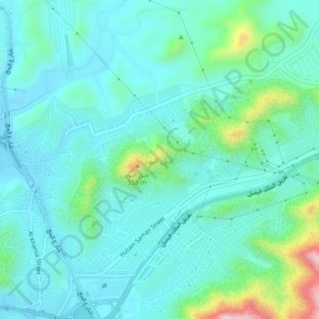
Name: جبل النور topographic map, elevation, terrain.
Average elevation: 388 m
Minimum elevation: 315 m
Maximum elevation: 706 m
Make a donation
Gear up for your next adventure:
As an Amazon Associate, this site earns from qualifying purchases at no extra cost to you.
Other topographic maps
Click on a map to view its topography, its elevation and its terrain.
Jabal ar Rahmah
Saudi Arabia > Makkah Region > Makkah Al Mukarramah
Mount Arafat (Arabic: جَبَل عَرَفَات, romanized: Jabal ʿArafāt, or جَبَل ٱلرَّحْمَة, Jabal ar-Raḥmah, 'Mountain of Mercy') is a granodiorite hill about 20 km (12 mi) southeast of Mecca, in the province of the same name in Saudi Arabia. It is approximately 70 m (230 ft) in…
Average elevation: 331 m
Make a donation
Gear up for your next adventure:
As an Amazon Associate, this site earns from qualifying purchases at no extra cost to you.
Jabal ar Rahmah
Saudi Arabia > Makkah Region > Makkah Al Mukarramah
Mount Arafat (Arabic: جَبَل عَرَفَات, romanized: Jabal ʿArafāt, or جَبَل ٱلرَّحْمَة, Jabal ar-Raḥmah, 'Mountain of Mercy') is a granodiorite hill about 20 km (12 mi) southeast of Mecca, in the province of the same name in Saudi Arabia. It is approximately 70 m (230 ft) in…
Average elevation: 331 m