
N'dalatando topographic map
Interactive map
Click on the map to display elevation.
About this map
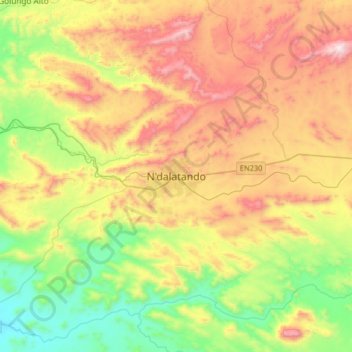
Name: N'dalatando topographic map, elevation, terrain.
Location: N'dalatando, Cuanza Norte Province, Angola (-9.45848 14.75450 -9.13848 15.07450)
Average elevation: 695 m
Minimum elevation: 233 m
Maximum elevation: 1,341 m
Other topographic maps
Click on a map to view its topography, its elevation and its terrain.
Banga
Angola > Cuanza Norte Province > Banga
Banga, Cuanza Norte Province, Angola
Average elevation: 882 m