
Eheim topographic map
Interactive map
Click on the map to display elevation.
About this map
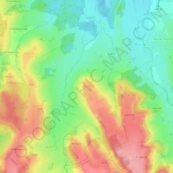
Name: Eheim topographic map, elevation, terrain.
Average elevation: 704 m
Minimum elevation: 646 m
Maximum elevation: 776 m
Other topographic maps
Click on a map to view its topography, its elevation and its terrain.
Bollenmühle
Deutschland > Bayern > Landkreis Unterallgäu > Ottobeuren > Ollarzried
Bollenmühle, Ollarzried, Ottobeuren, Landkreis Unterallgäu, Bayern, 87724, Deutschland
Average elevation: 767 m
Brüchlins
Deutschland > Bayern > Landkreis Unterallgäu > Ottobeuren
Brüchlins, Ottobeuren, Landkreis Unterallgäu, Bayern, 87749, Deutschland
Average elevation: 677 m
Guggenberg
Deutschland > Bayern > Landkreis Unterallgäu > Ottobeuren
Guggenberg, Ottobeuren, Landkreis Unterallgäu, Bayern, 87724, Deutschland
Average elevation: 696 m
Halbersberg
Deutschland > Bayern > Landkreis Unterallgäu > Ottobeuren > Langenberg
Halbersberg, Langenberg, Ottobeuren, Landkreis Unterallgäu, Bayern, 87724, Deutschland
Average elevation: 692 m