Geolocate

Lac Poisson topographic map

Click on the map to display elevation.

About this map

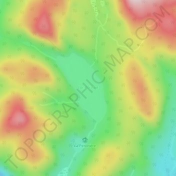
Name: Lac Poisson topographic map, elevation, terrain.

Location: Lac Poisson, Lac-Supérieur, Les Laurentides, Laurentides, Québec, Canada (46.31530 -74.47259 46.32603 -74.46128)

Average elevation: 577 m

Minimum elevation: 418 m

Maximum elevation: 756 m

Other topographic maps

Click on a map to view its topography, its elevation and its terrain.

Mont la Tuque

Canada > Québec > Les Laurentides > Lac-Supérieur

Average elevation: 379 m

Gear up for your next adventure:

🧼Technical Clothing Wash - Special soap to clean and restore waterproof membranes
🧷Tenacious Repair Tape - Instant fix for torn tents, jackets, or dry bags
📐Altimeters & Barometers - Tools for measuring altitude and air pressure
🧤Thermal Touchscreen Gloves - Stay warm while operating your GPS or smartphone camera
🛰️Handheld GPS Devices - Reliable GPS units for hiking and outdoor navigation

As an Amazon Associate, this site earns from qualifying purchases at no extra cost to you.