
Alta Mora topographic map
Interactive map
Click on the map to display elevation.
About this map
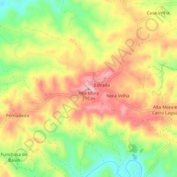
Name: Alta Mora topographic map, elevation, terrain.
Location: Alta Mora, Castro Marim, Faro, Portugal (37.30869 -7.60687 37.30879 -7.60677)
Average elevation: 192 m
Minimum elevation: 103 m
Maximum elevation: 267 m
Other topographic maps
Click on a map to view its topography, its elevation and its terrain.
Fonte do Penedo
Portugal > Faro > Castro Marim > Odeleite
Fonte do Penedo, Odeleite, Castro Marim, Faro, 8950-032, Portugal
Average elevation: 71 m