
Town of Clarence topographic map
Interactive map
Click on the map to display elevation.
About this map
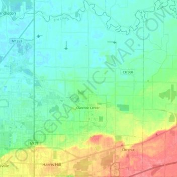
Name: Town of Clarence topographic map, elevation, terrain.
Location: Town of Clarence, Erie County, New York, United States (42.95467 -78.69695 43.09740 -78.57607)
Average elevation: 200 m
Minimum elevation: 175 m
Maximum elevation: 251 m
Other topographic maps
Click on a map to view its topography, its elevation and its terrain.
Onondaga Escarpment
United States > New York > Erie County > Village of Akron
Average elevation: 236 m