
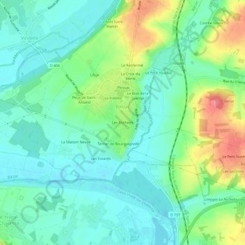
Les Rochiers topographic map
Interactive map
Click on the map to display elevation.
About this map
Name: Les Rochiers topographic map, elevation, terrain.
Average elevation: 54 m
Minimum elevation: 28 m
Maximum elevation: 112 m
Other topographic maps
Click on a map to view its topography, its elevation and its terrain.
La Font Saint-Martin
France > Nouvelle-Aquitaine > Charente > Balzac
La Font Saint-Martin, Balzac, Angoulême, Charente, Nouvelle-Aquitaine, France métropolitaine, 16430, France
Average elevation: 55 m
La Chapelle
France > Nouvelle-Aquitaine > Charente > Balzac
La Chapelle, Balzac, Angoulême, Charente, Nouvelle-Aquitaine, France métropolitaine, 16430, France
Average elevation: 53 m