
Chaskowo topographic map
Interactive map
Click on the map to display elevation.
About this map
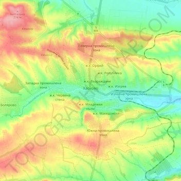
Name: Chaskowo topographic map, elevation, terrain.
Location: Chaskowo, Хасково, Oblast Chaskowo, 6300, Bulgarien (41.91609 25.49426 41.95075 25.60633)
Average elevation: 218 m
Minimum elevation: 165 m
Maximum elevation: 279 m
Other topographic maps
Click on a map to view its topography, its elevation and its terrain.
Карамандере
Bulgarien > Oblast Chaskowo > Книжовник
Карамандере, Книжовник, Хасково, Oblast Chaskowo, Bulgarien
Average elevation: 180 m