
London topographic map
Click on the map to display elevation.
About this map
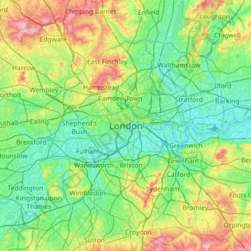
Name: London topographic map, elevation, terrain.
Location: London, Greater London, England, SW1A 2DX, United Kingdom (51.34732 -0.28765 51.66732 0.03235)
Average elevation: 42 m
Minimum elevation: -3 m
Maximum elevation: 163 m
England trails, hiking, mountain biking, running and outdoor activities
Other topographic maps
Click on a map to view its topography, its elevation and its terrain.
Wimbledon Common
United Kingdom > England > London
Putney Heath is around 160 hectares (400 acres) in size and sits at approximately 45 metres (148 feet) above sea level. Because of its elevation, from 1796 to 1816 Putney Heath hosted a station in the shutter telegraph chain, which connected the Admiralty in London to its naval ships in Portsmouth. This was…
Average elevation: 35 m
Hyde Park
United Kingdom > England > London
"It consists of a screen of handsome fluted Ionic columns, with three carriage entrance archways, two-foot entrances, a lodge, etc. The extent of the whole frontage is about 107 ft (33 m). The central entrance has a bold projection: the entablature is supported by four columns; and the volutes of the capitals…
Average elevation: 25 m
Bedford Square
United Kingdom > England > London
The house was threatened with demolition by the British Museum in 1860, along with Numbers 2 and 3 and the fourteen houses to the south in Bloomsbury Street, but nothing came of the museum's plans. Then in the early 1930s a new building was planned which would stand only 20 feet from the rear elevation of…
Average elevation: 30 m