
Rangiora River topographic map
Interactive map
Click on the map to display elevation.
About this map
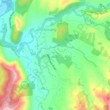
Name: Rangiora River topographic map, elevation, terrain.
Average elevation: 120 m
Minimum elevation: 36 m
Maximum elevation: 272 m
Other topographic maps
Click on a map to view its topography, its elevation and its terrain.
Ōtaki
New Zealand > Wellington > Kapiti Coast District
Ōtaki, Kāpiti Coast District, Wellington, 5512, New Zealand
Average elevation: 28 m