
Sarwara topographic map
Interactive map
Click on the map to display elevation.
About this map
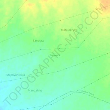
Name: Sarwara topographic map, elevation, terrain.
Location: Sarwara, Gunnor Tahsil, Panna, Madhya Pradesh, India (24.35750 80.25503 24.39750 80.29503)
Average elevation: 333 m
Minimum elevation: 320 m
Maximum elevation: 349 m
Other topographic maps
Click on a map to view its topography, its elevation and its terrain.
Palka
India > Madhya Pradesh > Gunnor Tahsil > Palka Kala
Palka, Palka Kala, Gunnor Tahsil, Panna District, Madhya Pradesh, India
Average elevation: 327 m
Rundh
India > Madhya Pradesh > Gunnor Tahsil > Pipariya Rundh > Rundh
Rundh, Pipariya Rundh, Gunnor Tahsil, Panna, Madhya Pradesh, India
Average elevation: 338 m