
Królewska Góra topographic map
Interactive map
Click on the map to display elevation.
About this map
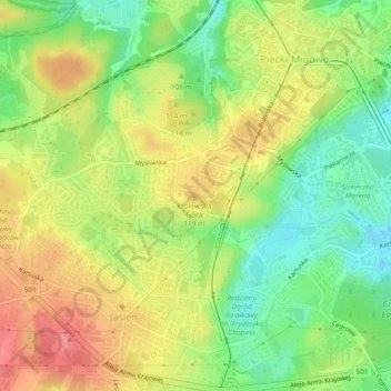
Name: Królewska Góra topographic map, elevation, terrain.
Location: Królewska Góra, Gdansk, Pomeranian Voivodeship, 80-125, Poland (54.34836 18.56849 54.34846 18.56859)
Average elevation: 95 m
Minimum elevation: 55 m
Maximum elevation: 136 m
Other topographic maps
Click on a map to view its topography, its elevation and its terrain.
Góra Gradowa
Poland > Pomeranian Voivodeship > Gdansk
Góra Gradowa, Gdansk, Pomeranian Voivodeship, 80-802, Poland
Average elevation: 21 m
Suchanino
Poland > Pomeranian Voivodeship > Gdansk
Suchanino, Gdansk, Pomeranian Voivodeship, Poland
Average elevation: 60 m
Rudniki
Poland > Pomeranian Voivodeship > Gdansk
Rudniki, Gdansk, Pomeranian Voivodeship, Poland
Average elevation: 1 m
Gdansk
Poland > Pomeranian Voivodeship > Gdansk
Gdansk, Pomeranian Voivodeship, Poland
Average elevation: 59 m
Śródmieście
Poland > Pomeranian Voivodeship > Gdansk
Śródmieście, Gdansk, Gdańsk, Pomeranian Voivodeship, Poland
Average elevation: 10 m