
Fountain topographic map
Click on the map to display elevation.
About this map
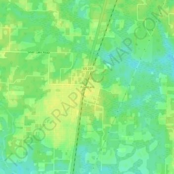
Name: Fountain topographic map, elevation, terrain.
Location: Fountain, Bay County, Florida, 32438, United States (30.45881 -85.43965 30.49881 -85.39965)
Average elevation: 51 m
Minimum elevation: 40 m
Maximum elevation: 60 m
Other topographic maps
Click on a map to view its topography, its elevation and its terrain.
Panama City Beach
United States > Florida > Bay County
Panama City Beach, located in Bay County, Florida, features a predominantly flat topography typical of coastal areas. Its terrain is characterized by low elevations, generally ranging between 20 to 30 feet (6 to 9 meters) above sea level. This flatness is interrupted by occasional sand dunes that rise up…
Average elevation: 2 m