
Kälberberg topographic map
Interactive map
Click on the map to display elevation.
About this map
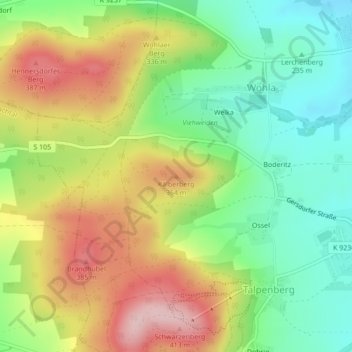
Name: Kälberberg topographic map, elevation, terrain.
Location: Kälberberg, Elstra, Bautzen, Sachsen, 01920, Deutschland (51.22584 14.10580 51.22594 14.10590)
Average elevation: 290 m
Minimum elevation: 199 m
Maximum elevation: 408 m
Other topographic maps
Click on a map to view its topography, its elevation and its terrain.
Elstra
Deutschland > Sachsen > Bautzen > Elstra
Elstra, Bautzen, Sachsen, 01920, Deutschland
Average elevation: 244 m
Grauberg
Deutschland > Sachsen > Bautzen > Elstra
Grauberg, Elstra, Bautzen, Sachsen, Deutschland
Average elevation: 280 m