
Make a donation
Gear up for your next adventure:
As an Amazon Associate, this site earns from qualifying purchases at no extra cost to you.
Hogs Back topographic map
Click on the map to display elevation.
Make a donation
Gear up for your next adventure:
As an Amazon Associate, this site earns from qualifying purchases at no extra cost to you.
About this map
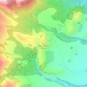
Name: Hogs Back topographic map, elevation, terrain.
Location: Hogs Back, Selwyn District, Canterbury, 7580, New Zealand (-43.18273 171.68741 -43.18263 171.68751)
Average elevation: 925 m
Minimum elevation: 732 m
Maximum elevation: 1,249 m
Make a donation
Gear up for your next adventure:
As an Amazon Associate, this site earns from qualifying purchases at no extra cost to you.
Other topographic maps
Click on a map to view its topography, its elevation and its terrain.
Darfield
New Zealand > Canterbury > Selwyn District
Located on the Canterbury Plains at an altitude of 193 m (633 ft) above sea level, the Köppen-Geiger climate classification for Darfield is Cfb (Oceanic). On several days a year, Darfield is subject to the nor'west Foehn wind, which is very dry and has the capability to raise the temperature by several…
Average elevation: 198 m
Make a donation
Gear up for your next adventure:
As an Amazon Associate, this site earns from qualifying purchases at no extra cost to you.
Make a donation
Gear up for your next adventure:
As an Amazon Associate, this site earns from qualifying purchases at no extra cost to you.
Make a donation
Gear up for your next adventure:
As an Amazon Associate, this site earns from qualifying purchases at no extra cost to you.