
Make a donation
Gear up for your next adventure:
As an Amazon Associate, this site earns from qualifying purchases at no extra cost to you.
Wymington topographic map
Click on the map to display elevation.
Make a donation
Gear up for your next adventure:
As an Amazon Associate, this site earns from qualifying purchases at no extra cost to you.
Wymington
During the Second World War, families in and near Wymington took in children evacuated from urban areas in response to bombing raids, as was typical of many rural towns and villages. In August, 1944 a damaged United States Army Air Forces B-17 "Miss Liberty Belle" based at nearby RAF Chelveston crashed in the village while returning to base on its 65th mission. The aircraft, having sustained battle damage over Saarbrucken following a raid over Merkwiller, was placed into a holding pattern above the village while other aircraft could land at the airfield. While waiting for clearance to land, the aircraft lost power to all but one engine and began losing altitude quickly. The crew narrowly avoided the church tower and school, colliding with a stand of trees and landing in a field on the southern edge of the village. Eight civilians as well as a soldier of the Czech Army billeted nearby rushed to the crash site and were able to pull all the crew members from the flaming wreckage, though only one survived. A B-17G on display at the Grissom Air Museum is painted with the markings of the aircraft that crashed in Wymington.
Make a donation
Gear up for your next adventure:
As an Amazon Associate, this site earns from qualifying purchases at no extra cost to you.
About this map
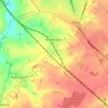
Name: Wymington topographic map, elevation, terrain.
Location: Wymington, Bedford, England, United Kingdom (52.24713 -0.63143 52.27948 -0.56571)
Average elevation: 86 m
Minimum elevation: 47 m
Maximum elevation: 108 m
Bedford trails, hiking, mountain biking, running and outdoor activities
Make a donation
Gear up for your next adventure:
As an Amazon Associate, this site earns from qualifying purchases at no extra cost to you.
Other topographic maps
Click on a map to view its topography, its elevation and its terrain.
Bedford
United Kingdom > England > Bedford
As with the rest of the United Kingdom, Bedford has a maritime climate, with a limited range of temperatures, and generally even rainfall throughout the year. The nearest Met Office weather station to Bedford is Bedford (Thurleigh) airport, about 6.5 miles (10.5 km) north of Bedford town centre at an elevation…
Average elevation: 37 m
Make a donation
Gear up for your next adventure:
As an Amazon Associate, this site earns from qualifying purchases at no extra cost to you.
Make a donation
Gear up for your next adventure:
As an Amazon Associate, this site earns from qualifying purchases at no extra cost to you.
Make a donation
Gear up for your next adventure:
As an Amazon Associate, this site earns from qualifying purchases at no extra cost to you.
Make a donation
Gear up for your next adventure:
As an Amazon Associate, this site earns from qualifying purchases at no extra cost to you.
Make a donation
Gear up for your next adventure:
As an Amazon Associate, this site earns from qualifying purchases at no extra cost to you.