
Thank you for supporting this site ❤️
Make a donation
Make a donation
Gear up for your next adventure:
As an Amazon Associate, this site earns from qualifying purchases at no extra cost to you.
Mbitom topographic map
Click on the map to display elevation.
Thank you for supporting this site ❤️
Make a donation
Make a donation
Gear up for your next adventure:
As an Amazon Associate, this site earns from qualifying purchases at no extra cost to you.
About this map
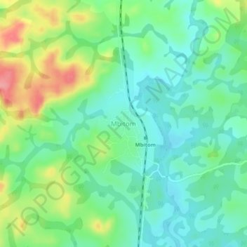
Name: Mbitom topographic map, elevation, terrain.
Location: Mbitom, Bétaré-Oya, Lom-et-Djérem, Région de l'Est, Cameroun (5.68750 13.30558 5.72750 13.34558)
Average elevation: 746 m
Minimum elevation: 714 m
Maximum elevation: 813 m
Thank you for supporting this site ❤️
Make a donation
Make a donation
Gear up for your next adventure:
As an Amazon Associate, this site earns from qualifying purchases at no extra cost to you.