Geolocate

Bais topographic map

Click on the map to display elevation.

About this map

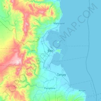
Name: Bais topographic map, elevation, terrain.

Location: Bais, Negros Oriental, Central Visayas, 6206, Philippines (9.43148 122.96130 9.75148 123.28130)

Average elevation: 176 m

Minimum elevation: -1 m

Maximum elevation: 915 m

Other topographic maps

Click on a map to view its topography, its elevation and its terrain.

La Paz

Philippines > Negros Oriental > Bais

Average elevation: 15 m

La Paz

Philippines > Negros Oriental > Bais

Average elevation: 15 m

Gear up for your next adventure:

🥤Hiking Water Bottles - Reusable bottles for hydration on the trail
🥫Expedition Meals - Lightweight, high-calorie nutrition for long-distance hikers
🧢Thermal Beanie Hats - Prevent heat loss from the head in windy summit conditions
🔦Waterproof LED Headlamps - Hands-free lighting for evening treks and emergency navigation
🚶Walking Pedometers - Simple distance tracking for casual trail walkers

As an Amazon Associate, this site earns from qualifying purchases at no extra cost to you.