Geolocate

Bhekra topographic map

Click on the map to display elevation.

About this map

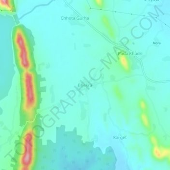
Name: Bhekra topographic map, elevation, terrain.

Location: Bhekra, Girwa Tehsil, Udaipur, Rajasthan, India (24.54321 73.82319 24.58321 73.86319)

Average elevation: 551 m

Minimum elevation: 518 m

Maximum elevation: 700 m

Other topographic maps

Click on a map to view its topography, its elevation and its terrain.

Jungle Safari Park

India > Rajasthan > Girwa Tehsil > Udaipur

Average elevation: 620 m

Pratap Park

India > Rajasthan > Girwa Tehsil > Udaipur

Average elevation: 608 m

Gear up for your next adventure:

🔋Lithium AA Batteries - Long-lasting power that performs well in cold mountain weather
🧢Waterproof Hiking Hats - Keep the rain off your face while studying topographic maps
🧴Sport Sunscreen Sticks - High-protection sunblock that won't run into your eyes on the trail
🧺Mesh Stuff Sacks - Breathable storage for wet gear or camp organization
🔋Rechargeable Batteries - Eco-friendly power for headlamps and older GPS units

As an Amazon Associate, this site earns from qualifying purchases at no extra cost to you.