Geolocate

Gobba di Rollin topographic map

Interactive map

Click on the map to display elevation.

About this map

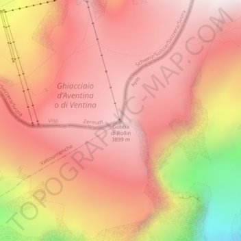
Name: Gobba di Rollin topographic map, elevation, terrain.

Location: Gobba di Rollin, Zermatt, Visp, Wallis, 3920, Switzerland (45.92398 7.73506 45.92408 7.73516)

Average elevation: 3,590 m

Minimum elevation: 2,795 m

Maximum elevation: 3,949 m

Other topographic maps

Click on a map to view its topography, its elevation and its terrain.

Matterhorn

Switzerland > Wallis > Visp > Zermatt

Matterhorn, Zermatt, Visp, Wallis, 3920, Switzerland

Average elevation: 3,295 m

Monte Rosa

Switzerland > Wallis > Visp > Zermatt

Monte Rosa, Zermatt, Visp, Wallis, 3920, Switzerland

Average elevation: 4,033 m

Gornera

Switzerland > Wallis > Visp > Zermatt

Gornera, Zermatt, Visp, Wallis, 3920, Switzerland

Average elevation: 2,226 m

Blatten

Switzerland > Wallis > Visp > Zermatt

Blatten, Zermatt, Visp, Wallis, 3920, Switzerland

Average elevation: 2,149 m