
Longview topographic map
Interactive map
Click on the map to display elevation.
About this map
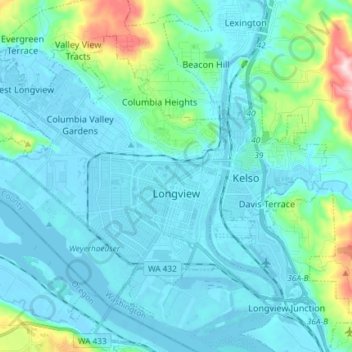
Name: Longview topographic map, elevation, terrain.
Location: Longview, Cowlitz County, Washington, United States (46.10163 -123.03935 46.18358 -122.89177)
Average elevation: 50 m
Minimum elevation: -5 m
Maximum elevation: 366 m
Longview is located in a small gorge, so its climate varies from that of its close neighbor, Portland. Longview is generally about 7 °F (4 °C) cooler than Portland. Located about 80 miles (130 km) inland across a stretch of relatively flat ground, the Longview skies can be overcast due to moisture from the Pacific Coast marine layer. The Columbia River gorge permits an exchange of air between eastern and western Washington. The direction and speed of air movement through the gorge is determined primarily by the pressure gradient between the eastern and western slopes of the mountains. Due to the gorge-like effect, marine pushes on summer evenings can frequently reach gusts up to 30 to 40 miles per hour (48 to 64 km/h) There have been gusts of up to 90 to 100 miles per hour (140 to 160 km/h), and over 100 miles per hour (160 km/h) at higher elevations.
Other topographic maps
Click on a map to view its topography, its elevation and its terrain.
Kelso
United States > Washington > Cowlitz County
Kelso, Cowlitz County, Washington, 98626, United States
Average elevation: 52 m
Silver Lake
United States > Washington > Cowlitz County
Silver Lake, Cowlitz County, Washington, 98645, United States
Average elevation: 159 m
West Side Highway
United States > Washington > Cowlitz County
West Side Highway, Beacon Hill, Cowlitz County, Washington, United States
Average elevation: 77 m
Pekin Ferry
United States > Washington > Cowlitz County
Pekin Ferry, Cowlitz County, Washington, United States
Average elevation: 41 m
Yale
United States > Washington > Cowlitz County
Yale, Cowlitz County, Washington, 98603, United States
Average elevation: 257 m
Eufaula
United States > Washington > Cowlitz County
Eufaula, Cowlitz County, Washington, United States
Average elevation: 126 m
Ryderwood
United States > Washington > Cowlitz County
Ryderwood, Cowlitz County, Washington, 98581, United States
Average elevation: 158 m
Toutle
United States > Washington > Cowlitz County
Toutle, Cowlitz County, Washington, 98645, United States
Average elevation: 173 m
Kelso Doughnut Hole
United States > Washington > Cowlitz County
Kelso Doughnut Hole, Cowlitz County, Washington, United States
Average elevation: 8 m
Kalama
United States > Washington > Cowlitz County
Kalama, Cowlitz County, Washington, 98625, United States
Average elevation: 58 m
Woodland
United States > Washington > Cowlitz County
Woodland, Cowlitz County, Washington, 98674, United States
Average elevation: 36 m
Coal Creek
United States > Washington > Cowlitz County
Coal Creek, Cowlitz County, Washington, United States
Average elevation: 132 m
Castle Rock
United States > Washington > Cowlitz County
Castle Rock, Cowlitz County, Washington, 98611, United States
Average elevation: 55 m
Rose Valley
United States > Washington > Cowlitz County
Rose Valley, Cowlitz County, Washington, 98609, United States
Average elevation: 148 m
Ariel
United States > Washington > Cowlitz County
Ariel, Cowlitz County, Washington, United States
Average elevation: 206 m
Woodland
United States > Washington > Cowlitz County > Woodland > Woodland
Woodland, Cowlitz County, Washington, 98674, United States
Average elevation: 58 m
Kelso
United States > Washington > Cowlitz County > Kelso > Kelso
Kelso, Cowlitz County, Washington, 98626, United States
Average elevation: 70 m
Cougar
United States > Washington > Cowlitz County
Cougar, Cowlitz County, Washington, 98616, United States
Average elevation: 311 m
Longview
United States > Washington > Cowlitz County > Longview > Longview
Longview, Cowlitz County, Washington, 98626, United States
Average elevation: 26 m
Stella
United States > Washington > Cowlitz County
Stella, Cowlitz County, Washington, United States
Average elevation: 59 m