
Egbedore topographic map
Interactive map
Click on the map to display elevation.
About this map
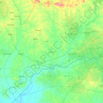
Name: Egbedore topographic map, elevation, terrain.
Location: Egbedore, Osun State, Nigeria (7.67856 4.32857 7.89871 4.56111)
Average elevation: 314 m
Minimum elevation: 238 m
Maximum elevation: 516 m
Other topographic maps
Click on a map to view its topography, its elevation and its terrain.
Asejire Reservoir
Nigeria > Osun State > Irewole
Asejire Reservoir, Irewole, Osun State, Nigeria
Average elevation: 175 m
Ikire Ile
Nigeria > Osun State > Ola Oluwa
Ikire Ile, Ola Oluwa, Osun State, Nigeria
Average elevation: 319 m
Ikire
Nigeria > Osun State > Ola Oluwa > Ikire
Ikire, Ola Oluwa, Osun State, Nigeria
Average elevation: 319 m