
St. David's Island topographic map
Interactive map
Click on the map to display elevation.
About this map
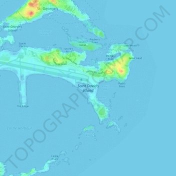
Name: St. David's Island topographic map, elevation, terrain.
Location: St. David's Island, Bermuda (32.34623 -64.70710 32.37225 -64.64724)
Average elevation: 2 m
Minimum elevation: -3 m
Maximum elevation: 46 m
Other topographic maps
Click on a map to view its topography, its elevation and its terrain.
Bermuda
Bermuda > Devonshire > North Shore Village
Bermuda consists of over 150 limestone islands, but especially five main islands, along the southern margin of the Bermuda Platform, one of three topographic highs found on the Bermuda Pedestal. This Bermuda Pedestal sits atop the Bermuda Rise, a mid-basin swell surrounded by abyssal plains. The Bermuda…
Average elevation: 0 m